






Strong thunderstorms in forecast for Pikes Peak region
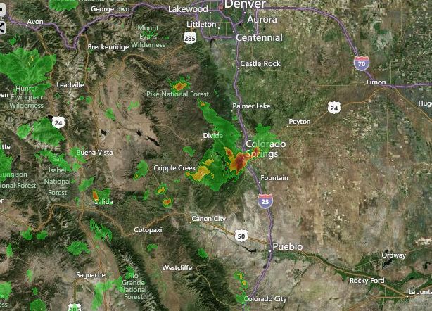
A large thunderstorm northwest of Colorado Springs could drop as much as .20 inches of rain over the Waldo Canyon burn scar and portions of El Paso County Monday, along with plenty of lightning and hail up to two inches in diameter, according to the National Weather Service.
The storm was spotted near Manitou Springs and traveling southeast at 20 mph toward Colorado Springs, with reported hail half-an-inch in diameter and winds in excess of 40 mph, the weather service said. The storm is expected to travel over Colorado Springs and reach Fort Carson and Security-Widefield about 2 p.m.
Colorado Springs and most of El Paso County, including Monument Ridge, Rampart Range and Teller County were included in the target area of the storm’s path, the weather service said.
For more information, click here.
Areas that could see stronger storm activity and higher amounts of rainfall are Camp Creek including Queens Canyon, Garden of the Gods, Rockledge Ranch, Fountain Creek, West Monument Creek, southern portions of the Air Force Academy, South Douglas Creek, Mountain Shadows, Holland Park, Peregrine and Rockrimmon, Sand Gulch including Chipita Park and North Douglas Creek, the weather service said.
There was no flood or small stream advisory issued, but the weather service said residents in the targeted areas should monitor local news and media outlets for additional information.
Over the southeast plains, the weather service predicted severe thunderstorms intensifying into the early evening, with winds possibly gusting up to 70 mph and hail about two inches in size.
Radar at 1:50 p.m. Monday.