


Temperatures starting to dip in the Pikes Peak region
Courtesy of the National Weather Service
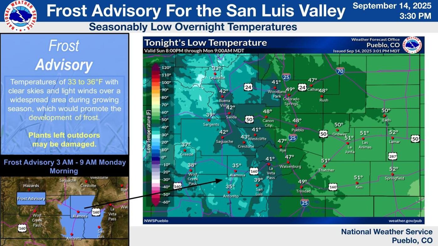
The National Weather Service in Pueblo issued a frost advisory for the San Luis Valley early Monday morning, reaching all the way to Woodland Park and creeping into Colorado Springs.
The frost advisory is in place from 3 to 9 a.m., impacting a majority of the western half of the state, according to the Weather Service. Colorado Springs and the Pikes Peak region is seeing much of these seasonably cold temperatures.
A Frost Advisory is in effect from 3 AM through 9 AM Monday morning for portions of the San Luis Valley, with near seasonal overnight lows expected across the rest of south central and southeast Colorado. Sensitive outdoor plants may be harmed if left untended! #cowx pic.twitter.com/nK6uScepvh
— NWS Pueblo (@NWSPueblo) September 14, 2025
Last year’s first fall freeze in the Springs was on Oct. 16, and the weather agency predicts that there is a 50% chance that we will have our first freeze this year by Oct. 3.
The following Freeze/Frost data for Alamosa, Colorado Springs and Pueblo have been compiled using NWS Pueblo and NCEI records: https://t.co/12zAgLJxIC #COWX pic.twitter.com/cnavoZ9RuZ
— NWS Pueblo (@NWSPueblo) September 14, 2025
This week’s nighttime lows dip into the 40s in Colorado Springs and the 30s in Woodland Park, with thunderstorms expected across the region. Daytime highs are expected to remain around the 70s.
Looking forward in Colorado Springs
Monday’s high is expected to be 80 degrees with a forecasted nighttime low of 52. Skies are expected to be clear with winds between 5-10 mph.
Tuesday’s high is projected to be 80 degrees and there is a 40% chance of evening thunderstorms. The forecasted nighttime low is 48, and thunderstorms are expected to linger.
Wednesday’s high is expected to drop to 69 degrees and a chance of thunderstorms remain throughout the day. Up to a quarter inch of rain is predicted. The nighttime low will be around 48 degrees.