


Weather alert: Severe thunderstorm warning covers Colorado Springs
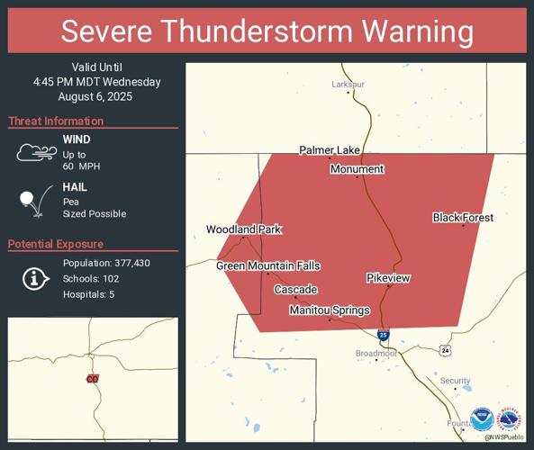
A severe thunderstorm warning is in effect until 4:45 p.m. for areas of El Paso County including Colorado Springs, Manitou Springs and Monument, according to the National Weather Service in Pueblo.
The warning area includes parts of Teller County, including Woodland Park.
Wednesday’s forecast
Colorado Springs residents can expect widespread haze throughout the region on Wednesday with a high of 94 and a 20% chance for afternoon showers.
“Wednesday will be a busy one for the state of Colorado, with everything from near record heat to wildfire smoke and thunderstorms expected to impact our weather today,” KOAA Meteorologist Alan Rose said.
By the afternoon, isolated thunderstorms will be possible, producing gusty winds and lightning with little rainfall.
“High fire danger will remain a concern in the mountains today, tomorrow, and Friday,” said Rose. “On top of gusty winds and low relative humidity, the threat of dry lightning today could lead to additional fire starts.”
Thursday will be even hotter than today, prompting a Heat Advisory for El Paso County from 11 AM to 8 PM, with some spots on the eastern plains reaching as hot as 105 degrees.
“Friday’s highs will remain in the middle 90s ahead of some cooler changes this weekend, Rose said. “Our next cold front on Saturday will drop highs back down to the upper 80s, which is still above our average high of 85 degrees.”
Temperatures in the lower 80s will follow into Sunday and Monday, with increasing chances during this time for afternoon showers.
Here’s this week’s weather forecast from the National Weather Service:
Thursday: A 10 percent chance of showers and thunderstorms after 2 pm. Mostly sunny, with a high near 94. Northwest wind 5 to 10 mph becoming southwest in the afternoon.
Friday: Partly sunny, with a high near 95. West southwest wind 10 to 15 mph.
Saturday: A 30 percent chance of showers and thunderstorms after noon. Mostly sunny, with a high near 90. Northwest wind 5 to 10 mph becoming southeast in the afternoon.
Sunday: A 40 percent chance of showers and thunderstorms after noon. Partly sunny, with a high near 84. West northwest wind 5 to 10 mph becoming east northeast in the afternoon.
Monday: A chance of showers and thunderstorms. Mostly sunny, with a high near 84. Northwest wind 5 to 10 mph becoming southeast in the afternoon.