


Weather alert: Storms force major flight delays in Colorado Springs, Denver
Christian Murdock, The Gazette
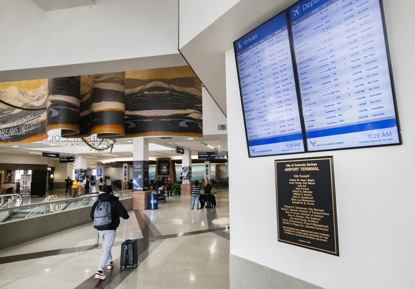
An active weather day Thursday including thunderstorms and flash flood warnings in parts of Colorado have resulted in numerous flight delays at the Colorado Springs Airport and Denver International Airport.
In Colorado Springs, more than 40 delays and two cancellation were listed by FlightAware as of 7:45 p.m. In Denver, more than 850 flights were delayed and 21 canceled, according to FlightAware.
Thunderstorms hit the region Thursday, bringing flash flood warnings for parts of El Paso, Pueblo, Fremont and Custer counties late in the afternoon.
Click or tap here for Colorado Springs Airport flight status updates.
Click or tap here for Denver International Airport flight status updates.
Click or tap here for updates from the National Weather Service in Pueblo on X.
Flash Flood Warning including Custer County, CO, Pueblo County, CO until 6:15 PM MDT pic.twitter.com/TYN3EfBhQB
— NWS Pueblo (@NWSPueblo) July 24, 2025
Thunderstorm development anticipated to increase in coverage and intensity through the afternoon! #cowx https://t.co/owgJ9ROlTc
— NWS Pueblo (@NWSPueblo) July 24, 2025
Thursday’s forecast
Colorado Springs can expect another day of clouds and thunderstorms with a high of 82.
Storms will be more widespread, and stronger, today across the Pikes Peak region, compared to the activity on Wednesday, according to Gazette news partner KOAA, and the National Weather Service.
“I expect a stationary boundary draped across southern Colorado to meander into the Front Range later this afternoon,” KOAA Meteorologist Casey Dorn said. “As it does so, storm lift, and wind shear, will both increase. These ingredients in the weather kitchen help to give us more robust storms.”
Storms today will be more organized than on Tuesday and Wednesday with some storms possible of heavy rain today, creating a potential for some isolated flash flooding concerns and potential hail and damaging winds.
A storm or two, could contain 1-1.5″ hail, and 60-70 mph wind gusts, according to KOAA.
“The earliest storms should form over the Palmer Divide, as early as noon,” said Dorn. “Storms across the rest of the Pikes Peak Region will follow the typical summertime trend of mid-afternoon, moving west to east off the mountains.”
These storms will contain plenty of lightning so its important to go inside when the storms arrive, even if they are not severe warned. Highs today will be a bit lower than on Wednesday, only topping out in the low 80s.
“Friday will retain isolated storm chances,” Dorn said. “Storms will favor the mountains, and the Palmer Divide, but isolated showers and thunderstorm chances will exist in central Colorado Springs. Temperatures start to climb a bit.”
Saturday through Monday are looking dry with highs returning to the 90s and plenty of sunshine in the forecast. Saturday might have isolated storms in the high country, and extremely spotty on Sunday.
“The monsoon returns Tuesday with that pattern continuing through much of next week providing more storm opportunities,” said Dorn.
Here’s this week’s weather forecast from the National Weather Service:
Friday: A 50% chance of showers and thunderstorms after noon. Mostly sunny, with a high near 85. Light and variable wind becoming south southeast 5 to 10 mph in the afternoon. New rainfall amounts of less than a tenth of an inch, except higher amounts possible in thunderstorms.
Saturday: A 10% chance of showers and thunderstorms after noon. Sunny, with a high near 92. Northwest wind 5 to 15 mph becoming south in the afternoon.
Sunday: Sunny, with a high near 92. West northwest wind 5 to 10 mph becoming south in the afternoon.
Monday: Mostly sunny, with a high near 92. Northwest wind around 5 mph becoming east southeast in the afternoon.