






Plotting Blodgett: Breaking down plan for beloved, expanded open space in Colorado Springs
One recent evening, in an auditorium of almost 100 northwest Colorado Springs neighbors worried or excited about the future of Blodgett Open Space, a presentation ended with a woman rising from her seat. She had a question for the audience.
“How many would like Blodgett to stay a nature preserve?”
She was met by a mix of cheers and jeers.
The moment illustrated the mixed feelings toward the city parks department’s proposed master plan for the popular, expanded open space.
Since March of 2023, officials have convened any and all for feedback. That’s while they’ve studied possibilities for hiking, mountain biking and more on parkland that in recent years has more than doubled since 2001, when the first 167 acres were established under the pointy, craggy peak looming over the city’s north side.
Amid the city’s last scheduled 30-day comment period for the plan, the recent meeting with neighbors was another attempt for officials to gain favor among people living close to Blodgett.
Not everyone would be happy, said David Deitemeyer, parks’ senior landscape architect overseeing the document guiding Blodgett’s next 15 to 20 years.
“We acknowledge there are different opinions,” Deitemeyer told the crowd. “Our goal is to balance all those different opinions and come up with this approach that generally reaches a consensus.”
A plan detailing expanded parking lots, new trail construction and closures along with conservation efforts is set to go to the city’s parks board and working committee of the Trails, Open Space and Parks (TOPS) funding program. Decision-making meetings are set for March and April.
Count one of those TOPS committee members a fan — mostly. Also living in the vicinity, Hank Scarangella said he still saw an imbalance between hiking and biking opportunities.
Otherwise, “I think (the city) responded really well to what the concerns were,” he said.
Of great concern are the area’s bighorn sheep. But Blodgett Open Space was never a “nature preserve,” contended another fan of the proposed plan, Gary Moring. He has lived nearby for 30 years.
“I don’t quite understand that, because my feeling is people have been using that for years,” he said.
The plan calls for people using the land in new ways for many more years — exciting for some, still worrisome for others.
Fears of ‘theme park’
One major theme Susan Davies noted from the year-long set of meetings and online surveys: “People were so adamant that there be a balance between recreation and conservation,” said the Trails and Open Space executive director.
Davies said she had not felt the sentiment to be so “pronounced” since 2014, when the parks department published a plan for its overall system.
“Of course, in those days, we didn’t have a big mountain bike population,” she said.
The interest has grown, and with it capabilities of bikes to travel farther and faster over rugged terrain. There are now two groups in the Springs advocating for better trails, while others are raising their voices against riders and their impacts.
Mountain bikers are “really well organized,” Davies said. That has been in their stated efforts to expand and preserve opportunities they’ve seen vanishing across city parks in the department’s mission to sweep and replace steep, unsanctioned trails deemed damaging and erosive, or creating conflicts with other trail goers.
Blodgett’s plan moves a historically proud multi-use city closer to a single-use philosophy that has slowly emerged here and faster across other busy Front Range trail systems.
Of the 13.7-mile system envisioned in the plan, 2.7 miles are designated for downhill bikers only.
“I think we’re going to see more and more of that, and we strongly support it,” said Medicine Wheel Trail Advocates Executive Director Cory Sutela. “It’s just absolutely necessary in order to meet the recreational desires and preserve user experiences. Nobody enjoys an unexpected confrontation between a downhill mountain biker and a hiker.”
Under the plan, hikers would have 1.1 miles for themselves. The recent neighborhood crowd grumbled at that.
The bike-optimized trails would be situated on the southern end of the open space — closer up the steep swath below the Pikeview Quarry. Should reclamation be successful by the owning company, the city could accept the quarry and develop what it has foreseen as a “world-class” bike park. (That development, should it happen, would be sorted through a separate, master plan-like process, officials have said.)
It all contributes to what opponents see as Blodgett Open Space becoming a “theme park” in the place of habitat. Also contributing to that perspective: two paragliding launch sites and one landing site, as outlined in the plan indicating “thorough coordination” with the Air Force Academy.
Equal or greater than “theme park” concerns have been concerns over security and wildfire. Some see bad actors and more chances for sparks being invited by a “Quarry Trailhead” parking lot that could be as large as 180 spaces.
The plan calls for fire mitigation, including as much as a 50% reduction of the property’s Gambel oak. The new parking lot could be equipped with an automatic gate, lights and cameras, according to the plan, which also calls for a phased build-out. The first phase would be 50 parking spots.
That’s part of what Deitemeyer called a unique “adaptive strategy” laid out by the plan.
“It allows us to manage the property with a little bit of flexibility based on changing conditions,” he said.
Recreation and conservation
Those conditions, Deitemeyer said, could be based on how people are impacting wildlife.
“What that might look like is a seasonal trail closure,” he said. Or maybe banning dogs from certain segments, he said, or “closing a trail entirely because of those wildlife concerns.”
For now, the plan outlines two wildlife corridors where “trail disturbances are minimized.” Those limit the trail system envisioned.
The 13.7 miles would come with a 22% reduction of current, user-made trails to be decommissioned.
“There will be a closure of more trails than will become system trails, and that is to enhance the wildlife corridor and habitat, and that is a good thing,” Sutela said. “The trails that are going in are going to be meaningful.”
On the southern, lesser-realized part of the open space — toward the quarry — the plan details a multi-use trail to a high point with a “spectacular view.” Two downhill bike lines drop from there.
A hiking-only loop is mapped for the more familiar, northern side of the open space. That side is “where it’s beautiful and green and a great place to have hiking only,” said Moring, the longtime neighbor and hiker.
While some would like additional hiking-only trails, the city seems more intent on parts of long-dreamed, multi-use trails.
The Park to Peak Trail is planned to connect Blodgett to Ute Valley, Austin Bluffs and Palmer parks. A new section of Chamberlain Trail is also planned — the big idea for a backcountry tour across the city’s foothills from Blodgett Peak to Cheyenne Mountain.
City planners are also hoping for more collaboration with the U.S. Forest Service. That’s “imperative,” the plan states, for the shared boundary with national forest that people have historically crossed to summit Blodgett Peak — an unsanctioned route that land managers have wanted to replace.
Deitemeyer said the city was positioned “to take some of the workload from (Forest Service) staff” to achieve “what we see as a high-priority need to provide sustainable access to the summit.”
Next steps
The cost to build out the full plan is estimated at around $6.9 million. That underscores what Davies saw as a problematic change by voters last year to the TOPS fund, which collects portions of sales tax revenues to acquire lands and maintain them.
That fund — collecting close to $13 million in recent years — has always been divvied up among certain categories, after administration costs.
On last year’s ballot, advocates successfully lobbied for 75% of the open space category (about $6.5 million a year) to be dedicated to land acquisition — honoring what those advocates saw as the original intent of TOPS, not maintenance.
But “many of us said the numbers don’t really work,” Davies said.
Scarangella, the longtime advocate and TOPS working committee member, was not opposed. “My only objection was, it tied the hands of the department,” he said.
Simply put, he said: It means projects under master plans such as Blodgett will happen slower.
Deitemeyer said $200,000 from the 2024 budget, along with pending grant money, would allow for the first 50 spots of the Quarry trailhead. From there, he said the goal would be to close unsanctioned trails and get busy on the Park to Peak, Chamberlain and downhill bike trails.
To see the full Blodgett Open Space plan and comment on it, go to: coloradosprings.gov/BlodgettMasterPlan
Comments are open until Feb. 18
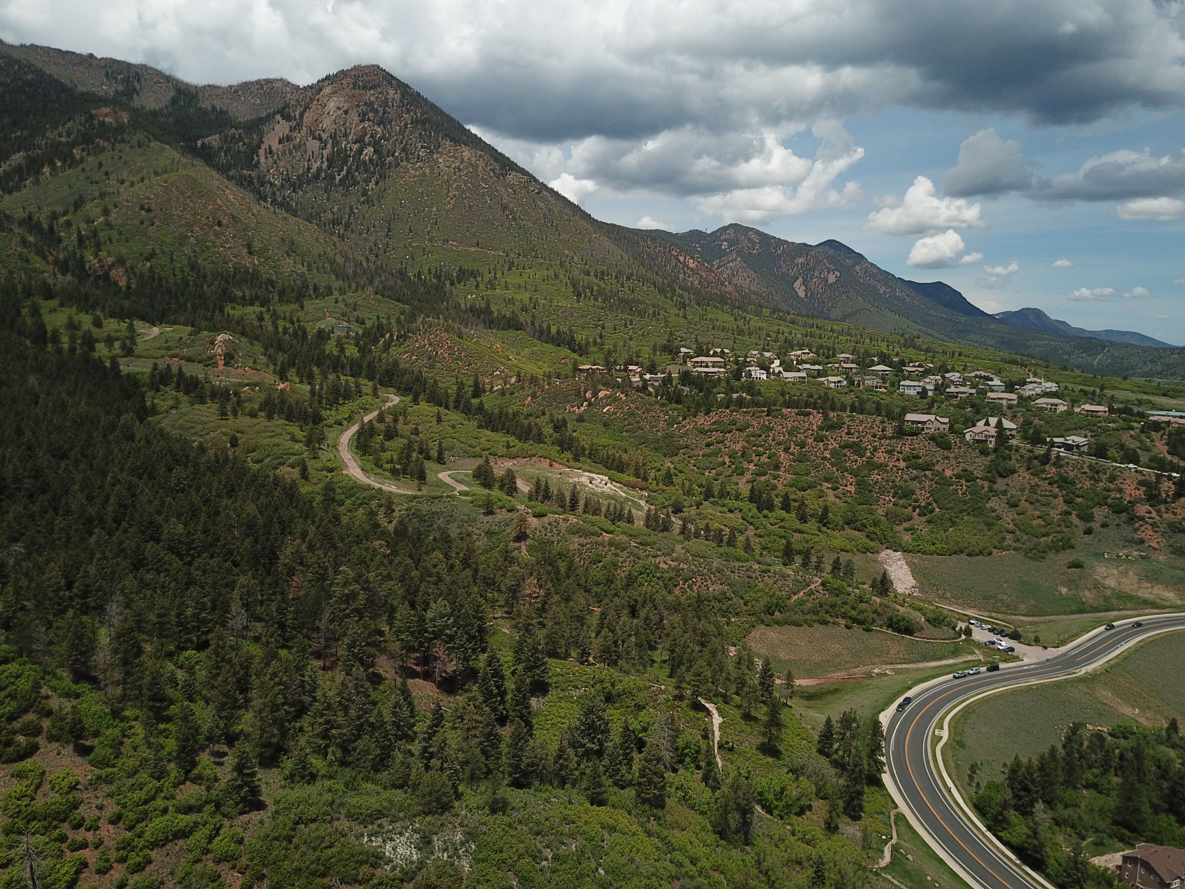
Aerial view of Blodgett Peak and its open space below in northwest Colorado Springs.
Hikers along the trail in the southern portion of Blodgett Open Space in Colorado Springs. Photo courtesy City of Colorado Springs
View of Pikeview Quarry from parts of Blodgett Open Space to be realized from a master plan. Photo courtesy City of Colorado Springs
View of Blodgett Peak from the open space on Colorado Springs’ northwest side. A master plan envisions new recreation and conservation efforts across the city’s expanded land. Photo courtesy City of Colorado Springs
A runner at Blodgett Open Space, the namesake peak in the distance.