






The Arctic is showing stunning winter warmth, and these scientists think they know why
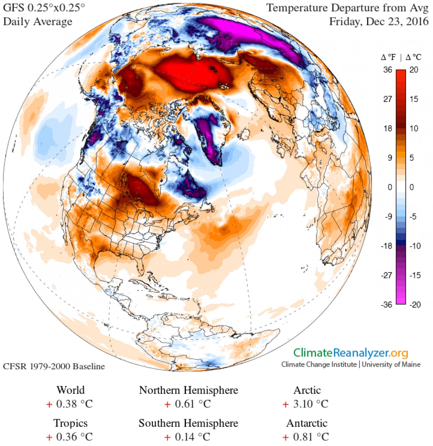
Last month, temperatures in the high Arctic spiked dramatically, some 36 degrees Fahrenheit above normal — a move that corresponded with record low levels of Arctic sea ice during a time of year when this ice is supposed to be expanding during the freezing polar night.
And now this week, as you can see above, we’re seeing another huge burst of Arctic warmth. A buoy close to the North Pole just reported temperatures close to the freezing point of 32 degrees Fahrenheit (0 Celsius), which is 10s of degrees warmer than normal for this time of year. Although it isn’t clear yet, we could now be in for another period when sea ice either pauses its spread across the Arctic ocean, or reverses course entirely.
But these bursts of Arctic warmth don’t stand alone — last month, extremely warm North Pole temperatures corresponded with extremely cold temperatures over Siberia. This week, meanwhile, there are large bursts of un-seasonally cold air over Alaska and Siberia once again.
It is all looking rather consistent with an outlook that has been dubbed “Warm Arctic, Cold Continents” — a notion that remains scientifically contentious but, if accurate, is deeply consequential for how climate change could unfold in the Northern Hemisphere winter.
The core idea here begins with the fact that the Arctic is warming up faster than the mid-latitudes and the equator, and losing its characteristic floating sea ice cover in the process. This also changes the Arctic atmosphere, the theory goes, and these changes interact with large scale atmospheric patterns that affect our weather (phenomena like the jet stream and the polar vortex). We won’t get into the details yet, but in essence, the result can be a kind of swapping of the cold air masses of the Arctic with the warm air masses to the south of them. The Arctic then gets hot (relatively), and the mid-latitudes — including sometimes, as during the infamous “polar vortex” event of 2013-2014, the United States — get cold.
Here’s an animation, provided by Jason Box of the Geological Survey of Denmark and Greenland, of what this might look like. It shows that both during the November major Arctic warming event, and again this week, temperatures over the Arctic ocean spiked far above their average, while temperatures over some high or mid-latitude land surfaces in the Northern Hemisphere fell well below average (the Arctic is at the far right):
The image, Box explained by email, “underscores the distinction between ocean and land and thus points to there being something to the pattern” of “Warm Arctic, Cold Continents.” He continued:
What are the impacts? Why should we care? For one, the patterns indicate a system changing state. For two: That change probably affects the frequency and persistence of weather, a hallmark of climate change; changing extremes… more hots and ironically sometimes sharper colds.
In recent years, several scientists have come up with different versions or incarnations of the “Warm Arctic, Cold Continents” idea. One of the best known is Rutgers University climate scientist and Arctic specialist Jennifer Francis, who published a 2012 paper with Stephen Vavrus of the University of Wisconsin-Madison arguing that the “Arctic amplification” of global warming was leading to a more wavy and slower-moving jet stream, and this in turn was leading to extreme weather as different atmospheric patterns became stuck in place. Their paper highlighted not only changes in winter, but also throughout the year.
“What I think we’ve been seeing this year has been totally consistent with the hypothesis that we’ve been working on,” Francis said in an interview of the recent Arctic drama. The jet stream is a global west-to-east flow (Francis often calls it a “river”) of air above our heads that carries with it weather we experience. But sometimes, the flow becomes quite elongated, looking much less like a tight loop around the planet and more like a series of slowly undulating waves.
“What I think is happening is that it’s been very warm in the Arctic all year long and this has helped favor a very wavy jet stream, which is what we’ve been seeing,” she continued, “and that has helped to pump a lot of extra heat and moisture up into the Arctic.”
Read the full story at The Washington Post