






Several parts of Colorado under avalanche warning after storm
Heavy snow will forever be a bane and a blessing to Colorado’s high country, where snowfall lures skiers and promises summer water, but also shuts down roads.
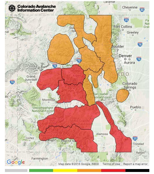
While the storm cycle has brought more than 40 inches to Wolf Creek and 30 inches on Monarch Pass, avalanche forecasters issued high danger alerts for the Front Range and mountain ranges in southern Colorado.
On the Colorado Avalanche Information Center website, it’s rare to see flashing red, high-avalanche-danger warnings, which urge backcountry enthusiasts to not even attempt moving through avalanche terrain.
On Tuesday, the website showed avalanche warnings for ranges around Gunnison and Aspen, as well as the San Juan and the Sangre De Cristo mountains. Forecasters also issued an avalanche advisory for the Front Range, extending from the mountains west of Fort Collins down to Pikes Peak.
The center rates avalanche danger on a five-level scale, from low danger to the rare extreme danger.
Avalanche danger is caused by weak snow that can fracture and send waves of heavy powder down a steep slope.
In many areas, Monday’s storm created the perfect conditions for a few kinds of avalanches, according to CAIC. Around the state, winds pummeled mountain sides, creating slabs of snow that can break off and slide away.
The new snow also sits on what forecasters call a weak layer, deeply buried in the snowpack. With enough weight on a steep slope, new snow can slide off the deeply buried layer, causing a large and dangerous avalanche.
But in Colorado, heavy snowpack has another impact beyond skiing conditions. Colorado’s mountains contain the headwaters for several rivers that flow to states east and west, and winter snowfall translates directly into the bounty of summer water.
While the crucial time for snowpack measuring is still months away – around March and April – nearly all of Colorado’s watersheds have above average snowfall. Monday’s statewide storm can only help.