






Coming snow brings winter reminder to Pikes Peak region
10:15 a.m. UPDATE
Colorado State Patrol says one person has died in a crash involving a car and a semi-truck Monday morning on Interstate 25 south of Fountain.
The wreck happened near the Ray Nixon Power Plant, according to trooper ate Reid of the state patrol.
Traffic is being detoured at mile marker 128.
The National Weather Service said scattered snow showers were expected to stick around the Pikes Peak region through 11 a.m. before tapering off.
“Please slow down and leave extra room,” Colorado Springs police said on Twitter.
Colorado Springs and Fountain police along with El Paso and Teller county sheriff’s departments went on accident alert status early Monday morning.
—
Colorado Springs was under a winter weather advisory early Monday after several inches of wet snow threatened to tangle the morning commute.
Most schools and military bases in the region started the day with delayed starts as snow plows worked to clear heavy slush from roads. Slips, splins and lideoffs tangles roads through the region. Downtown, Colorado Springs police cruisers sported tire chains.
The National Weather Service said scattered snow showers were expected to stick around the Pikes Peak region through 11 a.m. before tapering off.
“Please slow down and leave extra room,” Colorado Springs police said on Twitter.
East of downtown, School District 49 reported that it was closed due to the difficult conditions.
Click here for a full and up-to-the-minute updated list of delays.
Click here for an updated map of local traffic.
“Drifting snow is making it difficult to keep roads and school sites clear in northern and eastern sections,” the district wrote in an email.
Schools in Peyton and Ellicott also closed Monday.
El Paso County spokesman Dave Rose said plow crews were working to clear the worst of the roads.
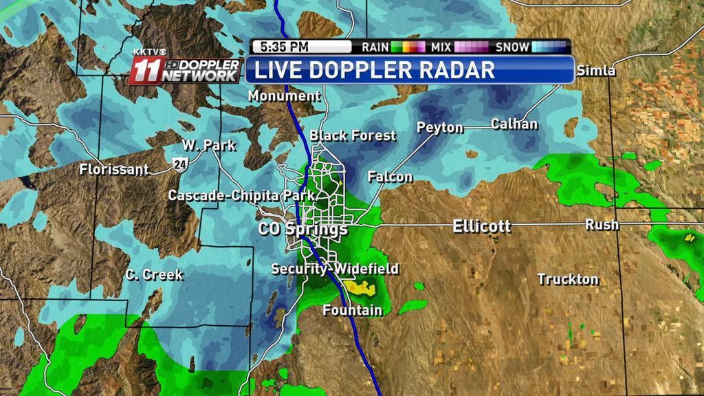
“El Paso County Public Services dispatched 32 trucks at 2 a.m. Monday to begin snow operation and 20 graders were added at 5:00 a.m.,” he wrote in an email. “Snow accumulations around the county vary widely from 1 inch to 14 inches reported and snow continues.”
Traffic headaches were reported in southern El Paso County, where a streatch of Highway 85 was closed in Fountain due to snow, ice and crashes. Wrecks were also reported on Highway 115 near Fort Carson.
Also, a major wreck was reported after 9 a.m. on Interstate 25 south of Fountain, near the Ray Nixon Power Plant. Traffic is being detoured at mile marker 128.
Drivers reported 6 inches of snow in northeastern Colorado Springs and more than a foot on the ground in Black Forest.
In the high country, a truck fire had shut down westbound Interste 70 near the Eisenhower Tunnel, the Colorado Department of Transportation said. It reopened at 9 a.m.
Pamela Evenson, a Weather Service forecaster, said the heaviest snow fell in northeatern El Paso County. One spot west of Ellicott reported seven inches on the ground, she said.
The winter weather was expected to stick around the Pikes Peak region through Tuesday as another system blows in bringing light snow.
The good news: Highs in the 50s are expected later in the week.
—
Snow began blanketing the Pikes Peak region late Sunday night, but the 1-to-2 inches that fell in many places will likely be the bulk of the snow that Colorado Springs will see this week.
“Kind of what you see is what you get,” said Stan Rose, a meteorologist with the National Weather Service in Pueblo.
The first impact we have early Monday morning comes in the form of several delayed starts for schools and military bases. Colorado Springs District 11, Academy 20, Lewis-Palmer 38 and Manitou Springs 14 are among many districts on two-hour delays.
Falcon 49 is closed Monday because of drifting snow in the district, according to reports on Twitter.
Colorado Springs and Fountain police along with El Paso and Teller county sheriff’s departments went on accident alert status early Monday morning.
While the snowfall and overnight temperatures in the teens are causing some trouble for Monday morning commuters, the worst of the storm likely will be long past by Monday evening, according to the weather service.
There is a chance that a second cold front will come through Tuesday and bring more snow to Colorado Springs, but that forecast was still in flux Sunday night, Rose said.
The storm could veer south, bringing heavier snowfall to Pueblo and areas south.
Between 1 and 3 inches of snow were in the forecast for Colorado Springs, said Emily Roehler, a meteorologist with Gazette news partner KKTV.
Brian Bledsoe, KKTV’s chief meteorologist, tweeted that 4 inches of snow had fallen at Barnes and Marksheffel roads by 9 p.m.
High temperatures Monday and Tuesday are expected to hover in the mid-20s and dip into the teens overnight.
That is in sharp contrast to Sunday, when highs reached the 50s.
El Paso County snowplow crews planned to begin a full callout of crews at 2 a.m. Monday to clear the roads for the morning commute, and the Colorado Springs Police Department went on accident alert about 8:30 p.m.
–
Contact Ryan Maye Handy: 636-0198
The old farmer with his hoe statue in the Demonstration Gardens looks like he’s hibernating Monday morning in Colorado Springs. (Jerilee Bennett, The Gazette)
Snow started falling Sunday night in downtown Colorado Springs. (Jerry Herman, The Gazette)
Fog and snow dominated the scene Monday morning on the east side of Colorado Springs. (Monica Mendoza, The Gazette)
Snow in the Falcon area Monday morning. (Courtesy Margaret Radford)