






Flash flood watch in effect for southern Colorado; slow-moving storms are big concern
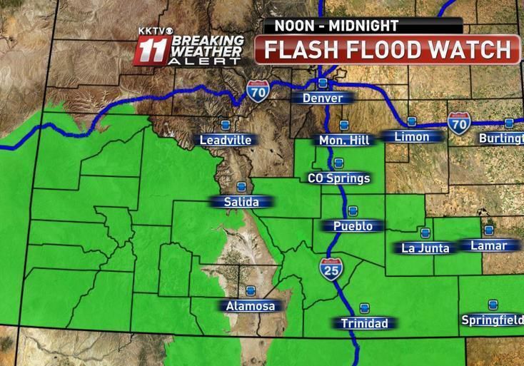
A new round of storms predicted to travel over El Paso, Pueblo and Fremont counties Monday prompted the National Weather Service to issue a flash flood watch spanning 12 hours, from noon to midnight.
The storm system is expected to start growing about noon over the mountains in western Colorado, slowly making its way east over the Pikes Peak region and potentially reaching the southeast plains by this evening, said weather service meteorologist Kathy Torgerson.
Sunday’s storms missed the Waldo Canyon burn scar, but there is no way to predict how the storms will behave with exact precision, Torgerson said. The peak window of potential flash flooding in Waldo Canyon, she added, could be between 2 and 6 p.m.
“The biggest concern we have is that the storms will move very slowly today,” Torgerson said. “So the storms will have quite some time to develop and expand.”
Monsoon moisture combined with low-level easterly upslope flow could produce numerous scattered thunderstorms and showers across much of south-central and southeast Colorado, the weather service said.
An added warning stated that recent rains had already saturated the ground and additional heavy rainfall could quickly lead to flash flooding.
“Burn scars and urban areas will also be highly susceptible to flash flooding through this evening,” the weather service stated.
The Sangre de Cristo Mountains, the Wet Mountain Valley, the San Juan Mountains and Rampart Range were also included in the flash flood watch, with a coverage area reaching as far east as the Kansas border.
Flooding of urban areas, creeks and normally dry drainages could be possible, especially after Sunday’s storms caused several waterways to flow above normal, the weather service stated. Any additionally rainfall could cause localized flooding, resulting in dangerous mud, debris and ash flows.
“The probability is greater than 50 percent, so we put out the watch to remind people to prepare early for any situation that could worsen and prompt a warning to be issued,” Torgerson said.
Although this July has been somewhat wetter than usual, Torgerson said the record rainfall measured for the month was 6.59 inches in 1930 over Colorado Springs. From July 1 to Monday, 3.08 inches of rain have fallen over the Colorado Springs airport and surpassed the normal measurement of 2.14 inches by more than half-an-inch, according to weather service records.
The weather service had not received reports of damage to homes or other property in southern portions of El Paso County, such as Fountain, Fort Carson, Security and Midway, where radars had estimated up to four inches of precipitation.
Weather service meteorologists confirmed 1.03 inches of rain had fallen on Midway, but did not have any other measurements for the county’s southern portion.
Monday’s forecast called for mostly cloudy skies and high temperatures in the low 70s, with 50 percent chance of scattered showers and thunderstorms.
Storms were predicted to stick around through the night with temperatures possibly dipping into the high 50s before midnight.