






Thunderstorm warning issued for El Paso County
Update 7:58 p.m.
Some bridges have been washed out along Fountain Creek near Green Mountain Falls.
Update 6 p.m.
A flash flood warning has been issued for West El Paso County and North East Teller County until 8:45 p.m.
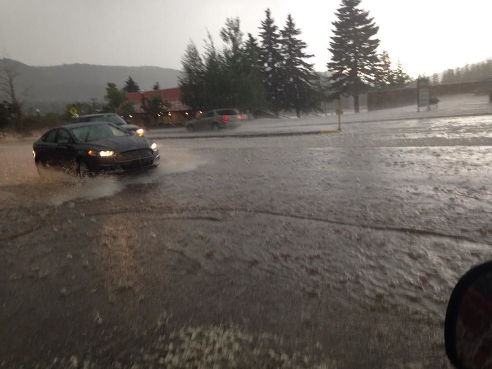
Voluntary evacuations are in place for houses along Fountain Creek in Green Mountain Falls, Chipita Park and Cascade, according to the Green Mountain Falls Chipita Park Fire Department. Flood waters are moving down Fountain Creek from Green Mountain Falls after heavy rain in Woodland Park.
– – – –
Update 5:57 p.m.
Voluntary evacuations in place for houses along Fountain Creek in Green Mountain Falls, Chipita Park and Cascade, according to firefighters.
A severe thunderstorm warning has been issued for North Central El Paso County until 6:15 p.m. The National Weather Service reports that the storm was located about 21 miles north of Colorado Springs, moving northeast at 30 mph.
– – – –
Update 5 p.m.
The National Weather Service in Pueblo has issued a small stream flood advisory for West Central El Paso County, including the Waldo Canyon burn scar until 7:30 p.m.Minor flooding is possible. Other areas impacted include western Colorado Springs, Woodland Park, the Air Force Academy, Manitou Springs, Green Mountain Falls, Chipita Park, Cascade and Crystola.A flash flood warning has been issued for Northeast Teller County, including Woodland Park, until 7 p.m.
– – – –
A severe thunderstorm watch for El Paso County and most of southcentral and southeastern Colorado went into effect Tuesday until 10 p.m., according to the National Weather Service in Pueblo.
A strong thunderstorm capable of producing nickel-sized hail and wind gusts up to 50 mph was spotted 19 miles southwest of Colorado Springs moving at 15 mph, the weather service said.
Colorado Springs and all of El Paso County, Canon City, eastern Fremont County, Teller and Pueblo counties were included in the path of the thunderstorm watch.
Frequent cloud-to-ground lightning and severe thunderstorms were predicted across the Pikes Peak region and into the southeastern plains, but although the tornado threat was considered low, Weather Service meteorologist Lisa Kriederman said it couldn’t be ruled out.
Storm patterns and cloud formations were being closely watched Tuesday above Denver, said Kriederman, because the forecast was similar to the conditions that caused Monday’s tornado warning.
“We’ll likely see storms with hail from an inch to two inches in diameter, and there’s always a possibility for funnel clouds; the winds are blowing and there’s plenty of turning,” Kriederman said of the northeastern Colorado’s forecast.
Tornados may not be too common along the Front Range, but weather in Colorado can be unpredictable, proven by the tornado warning that sent thousands of travelers at Denver International Airport rushing for shelter Monday.
Eighteen flights were diverted to the Colorado Springs Airport from DIA when the National Weather Service in Boulder issued a tornado warning about 6:15 p.m., causing delays of up to an hour-and-a-half and grounding or diverting a total of 42 aircraft, DIA spokesman Heath Montgomery said.
In El Paso County, thunderstorm warnings were issued about the same time but conditions were much more favorable and about 0.03 inches of rain were measured at the Colorado Springs Airport, the weather service said.
The severe weather up north served as a reminder of the importance of emergency protocols, said Colorado Springs airport spokeswoman Heather Lenard.
“The airport notifies all tenants and follows shelter-in-place protocol,” Lenard said. “The airport utilizes areas of the terminal that are considered the safest in severe weather: the first floor baggage claim area in stairwells, bathrooms and lower tunnels.”
The flight diversions, added Lenard, did not disrupt operations at the Colorado Springs airport and the passengers that came in from Denver stayed aboard their planes while they waited.
DIA officials said there was no hour-by-hour breakdown of how many travelers were delayed during the tornado warning, which expired about 6:40 p.m., but more than 160,000 people moved through the airport Monday
Thunderstorm cells were expected to linger over the Front Range until Wednesday night or Thursday and over the eastern plains through the end of the week, the weather service said.
Pic of the flooding in Woodland Park. Stay safe out there! Thanks to Tina for sending the pic! via KKTV.
Doppler radar at 2:45 p.m. Tuesday, from KKTV