






Off-roading tips to see fall colors away from the crowds
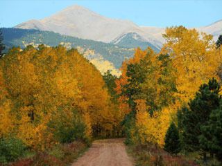
For every four-wheel-drive road in Colorado, there’s a driver in a Ford Taurus station wagon willing to give it a try. But if you care about your car, you might not be willing to take it off the highway. Or, you might not know how much your car or your nerves can handle.
So every fall, as you plan your trip to see the turning of the aspens, you play it safe, sticking to the crowded highways, jockeying for a parking space on packed pull-outs, and looking for a new angle on that old view of the golden high country.
This year, in the spirit of exploration, we suggest you turn off the highway and steer away from the madding crowds.
“Getting off the pavement doesn’t have to be a scary thing,” says Charles Wells, author of six four-wheel drive guidebooks for Colorado, Arizona, California and Utah, and a new all-terrain-vehicle guide to Moab, Utah.
Wells, who lives in Monument, has been four-wheeling for years, and eight years ago he published his first guidebook. He drives nearly all the trails in his books and rates them, from easy to extremely difficult, such as Independence Trail northeast of Cañon City:
“When you see this trail, it is hard to believe that any kind of vehicle can get through it,” Wells writes.
“Tall rock walls and giant boulders are the norm. Expect rollovers and vehicle damage. Heavy-duty roll cage and giant tires a must.”
Those are the kind of trails best left to the most hard-core four-wheelers with specialized equipment and experience. Let them play on the boulders and ledges of Independence, and find your own adventure on less extreme roads.
“It’s just fun to get out there,” Wells says. “It’s kind of like you’re on a discovery mission. Sometimes, even though you know you aren’t the first to drive down a road or trail, you can feel like you’re the only adventurer.”
Wells says that even drivers with less-muscular vehicles — passenger cars or light-duty sport utility vehicles such as the Honda CRV — can get off the main drag.
“Colorado has so many places you can go in a motorized vehicle. It’s endless.”
Scott Reibel of Colorado Springs used to frequent trails such as the panic-inducing Independence in his Jeep, but nowadays he uses his Hummer H2 to reach hunting, fishing and camping spots.
“I like technically demanding trails and continue wheeling those until I get them,” Reibel says.
“But I like the more comfortable stuff today. The beauty of getting out there is what keeps me going back. There’s so much of Colorado to enjoy, but most people confine themselves to Colorado Springs, Denver, Pueblo. They never leave the main roads.
“You miss a lot if you do that.”
WHERE TO HIT THE ROAD
Check out these drives for your fall leaf-peeping. Some are Out There favorites; others were suggested by fourwheel guidebook author Charles Wells.
We’ve divided them into drives suitable for passenger cars and drives better suited for light-duty sport utility vehicles (those without lowrange gearing options). None of these are on pavement. Some are narrow, and some have washboard sections or rocky sections that might change when wet. We’ll get you to the starting point. You’ll need a good map to proceed; Wells suggests the DeLorme Colorado Atlas & Gazetteer or Trails Illustrated maps. For information on Charles Wells’ guidebooks, go to www.funtreks.com.
FOR PASSENGER CARS
Nearby
Old Stage Road to Gold Camp Road, Colorado Springs to Victor
To start: Take Nevada Avenue south; turn west on Lake Avenue. At The Broadmoor, turn right and circle around behind it. On El Pomar Road, turn south. At Penrose Boulevard, bear left and continue south. Turn right and head uphill on Old Stage. The road merges with Gold Camp Road in 7 miles.
Features: Views of the eastern plains and the city, thick stands of aspen, rock formations.
Phantom Canyon Road
To start: Take Colorado 115 to U.S. 50, just outside Penrose. Turn right and drive west on 50, watching for a sign to right for Phantom Canyon Road (Colorado 67).
Features: Bridges and tunnels on a historic railroad bed.
A little farther
Guanella Pass Road
To start: Take I-25 north to Denver, then C-470, then I-70 west to exit 228 in Georgetown. Follow the signs from the Gateway Visitors Center. The byway ends in Grant.
Features: Great views of Mounts Evans and Bierstadt; aspen stands intermingled with dark pines.
East side of Weston Pass Road
To start: Take U.S. 24 west to Hartsel; turn right on Colorado 9 and left on U.S. 285. Go south 4.7 miles and turn right on County Road 5 after mile marker 178. Follow sign to Weston Pass. Stay right when you meet County Road 22. Stay left at 7.6 miles. Go past Weston Pass campground at 11 miles. Stay left at 15.7 miles. You’ll reach the pass at 15.9 miles. Turn around here if you don’t have a high-clearance vehicle —the west side is much rougher.
Features: Pleasant drive through mixed-growth forest.
Boreas Pass Road
To start: From downtown Breckenridge, head south on Colorado 9 and turn left on Boreas Pass Road. This road can be rutted after a rainstorm, but passenger cars are frequently driven on it.
Features: Stunning aspen canopy that frames this historic road.
Shrine Pass to Holy Cross Shrine (observation deck).
To start: From Denver, take I-70 west and exit at 190 between Copper Mountain and Vail. There’s a large rest area here. Continue west on Shrine Pass Road where paved road turns left for the rest area. If you want to continue to Red Cliff on the other side, you should have a four-wheel-drive vehicle.
Feature: Views of Mount of the Holy Cross.
Even farther
Kebler Pass near Crested Butte
To start: From Crested Butte, go west on Whiterock Avenue off 135. This becomes County Road 12. Bear left at a gated road. Other side of the pass is wide with a gentle descent.
Features: Scenic stops at Irwin Lake, Lost Lake. Sweeping views of Crested Butte’s massive stands of aspen.
FOR LIGHT-DUTY SUVs
Nearby
Rampart Range Road, from Garden of the Gods to Woodland Park
To start: Get on this road just past Balanced Rock in Garden of the Gods. Head up and around, past the Cedar Heights community and the shooting range. Rocky surface with some washouts in the first few miles; graded and better as you get higher.
Features: Views of Garden of the Gods and Colorado Springs; great picture-taking spots for views of Pikes Peak.
Mount Herman Road above Monument
To start: Take I-25 north to Monument and take Exit 161. From light on west side of overpass, head west on Second Street through town. Cross the railroad tracks and turn left on Mitchell Avenue. Go 0.6 miles and turn right on Mount Herman Road. Head west 2.4 miles and turn left on Forest Road 320. Gravel with some rocky spots and washouts.
Features: Views of the Front Range, Air Force Academy, Pikes Peak.
Phantom Creek, Signal Butte, near Divide
To start: Take U.S. 24 west to Divide; turn right at the light onto County Road 5. At 0.5 miles, curve left onto County Road 15. Go 2.9 miles and bear right. After an additional 5.9 miles, turn right on Phantom Creek Road 363. Rutted and bumpy, with tight downhill switchbacks on the downhill side.
Features: Forest trip with views of Pikes Peak.
Farther
Shrine Pass Road, all the way to Red Cliff
To start: Follow directions in the passenger-car section, but after you reach the shrine, continue. The road on the other side is narrower and rougher and can be muddy.
Features: Ends in the tiny town of Red Cliff; historic road with views of Mount of the Holy Cross.
Even farther
Last Dollar Road from Telluride to Ridgway
To start: From Ridgway, go west on Colorado 62 for 12 miles. Turn left on Last Dollar Road 0.8 miles west of mile marker 12.
Features: Scenic alternative link between these two towns; fall colors, views of ranchland and forest.
Paradise Divide/Gothic Road near Crested Butte
To start: From Crested Butte, take Colorado 135 north 0.8 miles from the visitor center; turn left on Slate River Road 734.
Features: Considered one of the most beautiful drives in the state. Wide graded road that narrows to a shelf road as it nears Paradise Divide.
DRIVE THE SKI RESORTS
Use light-duty SUVs or other fourwheel drive vehicles to check out these roads that take you up through ski areas in the off-season:
Mill Creek Road through Vail
To start: Drive I-70 from Denver to Vail and take Exit 176. Drive south through the roundabout on the south side of the interstate and onto Vail Road. The road will curve to the left and enter a parking area behind the Lodge Tower. Continue driving east under the chairlift to an intersection by Vista Bahn Lift. Turn right and head uphill on Mill Creek Road, Forest Road 710.
Features: A route through the heart of Vail Ski Area to the top of Red Peak. Mostly easy, getting narrower and rutted the last few miles.
Red and White Mountain Road (Forest Road 734 beyond Forest Road 700) out of Vail
To start: From I-70, take Exit 176 for Vail. Turn north and drive on North Frontage Road west to Red Sandstone Road No. 700. Continue up 700 for seven miles to a sign for Red and White Mountain Road 734. Turn left here. Rated moderate in the summer, when it can get slick in wet conditions; easier in the fall.
Features: Numerous scenic views from high-mountain meadows.
Aspen Summer Road, up the flank of Aspen Mountain.
To start: From Main Street in downtown Aspen, drive to Ute Avenue. Turn left and then right on Aspen Alps South Road. Follow that road to the ski area where Aspen Summer Road No. 123 begins.
Features: Switchbacks up the front of Aspen Mountain; reaches Sundeck Restaurant at the top of the mountain.
Photo by Bryan Oller/The Gazette