


Buffalo Peaks: Where the crowds don’t roam
UNVISITED COLORADO: This story is part of a series about off-the-beaten-track parts of Colorado that are worth a visit.
Buffalo Peaks Wilderness • “High potential for solitude.”That’s what the U.S. Forest Service says about the Buffalo Peaks Wilderness in Park County, a landscape of humped peaks, lush rolling meadows surrounded by lodgepole pines and hard-tumbling creeks that roar like nature’s window fan.I was skeptical. This place is 90 miles from the largest population center in the Rockies, Colorado’s Front Range, and is accessible on good roads.So often on summer weekends in Colorado, crowds in the high country seem to be as reliable as afternoon thunderstorms. Voices carry on the wind, other campfires shimmer in the distance and hikers loom around every turn, always reminding you just how many people you are sharing your intimate wilderness experience with.High in the wilderness, in a place called Buffalo Meadows, I was proven wrong. It’s a place that begs to be visited by anyone who has spent one too many noisy nights at a campground or fought for a place to pose for a picture on a crowded fourteener summit.This is unvisited Colorado.Our journey began at a trailhead off Forest Service Road 431, Buffalo Peaks Road. Though the wilderness is accessible from all sides, the best roads are this and the Weston Pass Road, both of which provide ready access to the hallmark experience here, an 11-mile loop trail through the heart of the wilderness.The namesake peaks are visible from U.S. Highway 285, en route to Buena Vista. Rounded and unexceptional-looking, these volcanic mountains form the southern terminus of the Mosquito Range, which rises to the popular fourteener Mount Sherman a few miles to the north. The area became wilderness in 1993.The Mosquitoes are known for old mines, encroaching roads, weekend crowds and easy summit walks. Buffalo Peaks Wilderness has only the latter.Most people hike the loop counterclockwise, heading up the Rich Creek Trail, connecting with the Rough and Tumbling Trail in Buffalo Meadows. It is considered one of the region’s best short backpack trips — though a long day trip is possible.Aspen woodlands gave way to pine forests as we climbed ever upward on the gentle trail, hard-flowing Rich Creek never out of earshot. Finally, we burst into a grassy valley, where wildflowers were abundant and wooded hillsides surrounded. A couple more flat miles led to Buffalo Meadows.This was not total solitude. Two other groups shared the area, though they were far enough away that we could forget their presence, and a couple fished in Rough and Tumble Creek, which begins high in the valley.We watched the sun set from our campsite in the trees, and gazed up at a sky shining with a million stars.Later, I tried not to think about the black bear that attacked a hunter in the wilderness in 1998 or the three mountain lions that stalked a Forest Service employee here in 2005.We took a half-day side trip up the Rough and Tumbling Trail, and where it starts to descend, plunged left up the side of West Buffalo Peak.There is no trail, but it was easy to find a route up the steep, grassy flank, and within an hour-and-a-half we were on top of the 13,326-foot dome.To the west, the Collegiate Peaks formed an imposing wall, while Pikes Peak glittered in the distance. Unfortunately, we saw none of the bighorn sheep that call these mountains home.Other hiking routes to the top of these rarely climbed peaks are possible, though none seems to involve much of a trail. The Web site www.summitpost.org offers the best guidance.We returned to camp, packed up and, somewhat ruefully, left the meadows, finishing the loop on Rough and Tumble Trail.There are a few other trails and entry points, but the entire wilderness has only 18 miles of trail, so the loop is the best chance to see what it has to offer.We saw about 15 people over two days, not bad considering how many Front Range denizens fly past these peaks on the highway on summer weekends.It is hard to put into words what makes this place spectacular. There were no jagged peaks, stunning waterfalls or fourteeners to bag.Maybe we are just so used to sharing Colorado’s natural wonders with so many people in the summer that the lack of a crowd was enough to make it so.
Here are the details:
BUFFALO PEAKS WILDERNESSElevation: 9,200 feet to 13,326 feet, the summit of West Buffalo PeakArea: 43,410 acresYear designated: 1993Getting there: Take U.S. Highway 24 west, head north on U.S. Highway 285. For the quickest access to Buffalo Meadows and the peaks, turn left on Forest Service Road 431, Buffalo Peaks Road, and drive eight miles.For the Weston Pass Campground, where most people begin the wilderness loop trail, stay on 285 and turn left on Weston Pass Road. Access from the west side of the wilderness requires four-wheel-drive, high-clearance vehicles.Camping: Free car camping is available along Buffalo Peaks Road. For more facilities, but a nightly fee, try Weston Pass Campground on the edge of the wilderness on Weston Pass Road or Buffalo Springs Campground on Buffalo Peaks Road.No permit is needed for backcountry camping. The best spots, with established fire rings, are in trees around Buffalo Meadows.Special considerations: Standard wilderness rules apply: no bikes or motorized vehicles, and groups are limited to 25 people and stock animals.
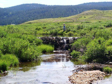
Visitors to Buffalo Peaks Wilderness area might encounter a few other souls, but it’s a quiet getaway nonetheless. Photo by R. SCOTT RAPPOLD, THE GAZETTE